Troubled history of Assam-Mizoram Border
- Posted By
10Pointer
- Categories
Polity & Governance
- Published
16th Jul, 2021
-
-
Context
The recent attack on workers with grenades in Cachar district, Assam, near the Mizoram border has put the spotlight back on the long-standing inter-state boundary issue in the Northeast, particularly between Assam and the other states in the region.
-
Background
- The border dispute between the two states is not a new one; the dispute has persisted for a while.
- Assam says the boundary demarcated in 1933 notification should be maintained while Mizoram insists that the same drawn in the Bengal Eastern Frontier Regulation, 1875 should be the actual boundary.
- Violence broke out in October last year and in February this year, in which some schools were even allegedly bombed by miscreants from Mizoram's side.
- Mizoram, on the other hand, claimed that the schools were set up by Assam officials in their land.
-
Analysis
What is the dispute?
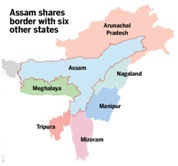
- Three districts of Assam’s Barak Valley (Cachar, Karimganj and Hailakandi) share a 164-km long border with three districts of Mizoram (Aizawl, Kolasib and Mamit).
- Since Mizoram’s formation, there have been border disputes between the two states, which led to clashes in August 2020 and February this year.
|
Mizoram
- Formerly known as Lushai Hills, Mizoram is located on the southern fringes of Northeast India.
- Mizoram was part of Assam until 1972, when it was carved out as a Union Territory.
- Mizoram became the 23rd state of India on 20 February 1987 following the Mizoram Accord between the erstwhile underground Mizo National Front (MNF) and the Centre, which ended 20 years insurgency in the state.
- The state shares
- Indian States: borders with three north-eastern states of Tripura, Assam and Manipur
- Neighbouring countries: It shares a 722-km border with the neighbouring countries of Myanmar and Bangladesh.
|
-
What is at the heart of the conflict?
- At the heart of the conflict, there are two documents:
- 1875 notification: It differentiates between the Lushai Hills and Cachar Hills.
- 1933 notification: It demarcates the Lushai Hills (from where Mizoram has been carved out) and Manipur
- Mizoram does not follow the 1993 notification, since the boundary was demarcated before the formation of the Mizo state.
|
Major steps to accommodate the territorial aspirations of north-eastern states
- Arunachal Pradesh was reorganized into a Union Territory in 1972.
- It was upgraded to a full-fledged state in 1987.
- Similarly, the status of a ‘state’ were granted to-
- Nagaland in 1963
- Meghalaya in 1972
- Mizoram in 1987
|
|
Alteration of boundaries
- India is a sovereign state which has the power to alter the boundaries of its states.
- The Parliament is empowered by the Constitution (Article 2 and Article 3 of the Indian Constitution) to alter the boundary or names, etc. of the States, without their consent.
- A new State may be formed and its area, boundary or names of the existing States may be altered by simple majority (majority of more than 50% of the members present and voting in the House) in the Parliament.
- The boundary of States can be demarcated by the Central government.
- The Parliament can form a new State or alter the boundary of existing States if certain conditions are fulfilled.
|
-
Why Assam connects all north-eastern border disputes?
- Assam has been the common strand that connects all these North Eastern border disputes.
- The root cause of all these inter-state border disputes are the result of a decision to carve out new political states out of Assam which was necessitated by compelling circumstances based on the prevailing external and internal situation in the region during the 1960s highlighted the urgent need to effectively integrate this sensitive area with mainland India.
- The 1962 border conflict with China and numerous ethnic insurgencies that spawned in the region threatened the unity and integrity of the country.
-
What leads to these often clashes?
- Unmarked border: The border between the two neighbouring states is an imaginary line that changes with the natural obstacles of rivers, hills, valleys and forests.
|
Determination of state borders
- British India was divided into various princely states.
- Upon independence, these princely states were transformed into provinces and were provided with an opportunity to join India or Pakistan.
- India became a “Union of States” after the Constitution came into force on 26 January, 1950.
- However, in the early 1950s the movement to reorganize the states on the basis of language started taking place.
- Linguistic lines to be taken into consideration for the purpose of state reorganization were being asked by people.
|
- Lack of focus on ethnic boundaries: North-eastern states were hurriedly carved out of Assam without paying much attention to the tribal realities on the ground and because these freshly created state boundaries did not strictly conform to the ethnic boundaries of the region.
- Lack of mechanism for joint resolution: The Central government did not create any mechanism that allowed these states to jointly address these disputes and left these boundary issues for a resolution at a later date.
|
Major inter-state disputes in India
Assam – Nagaland (Boundary: 434 kilometer)
- Area of dispute: Assam districts of Sivasagar, Jorhat, and Golaghat.
Assam – Meghalaya
- Area of dispute: Mikir Hills
Gujarat – Rajasthan
- Area of dispute: Mangadh Hill, located on the border of the two states. Gujarat claims half of the hill, while Rajasthan claims the entire hill is theirs.
Karnataka- Kerala
- Area of dispute: district of Kasaragod
Orissa – West Bengal
- Area of dispute: 82 villages under Jaleswar and Bhogarai blocks in Balasore district
Arunachal Pradesh and Assam:
- Arunachal Pradesh claims territory in Assam based on history.
Meghalaya and Assam:
- Assam and Meghalaya don't have a major boundary dispute, the reply said. But Nagaland claims 5,000 sq miles of territory in Assam "on historical grounds".
Others
- Orissa and Andhra Pradesh: Between Orissa and Andhra Pradesh, the boundary dispute relates to 63 villages falling presently in Orissa. But neither government has asked for Central intervention.
- Orissa and Jharkhand: Similarly, Orissa and Jharkhand have a boundary dispute relating to seven villages of the Mayurbhang and Keonjhar districts. Orissa has claimed territories in the former princely states of Seraikela and Kharsuan, now in Jharkhand.
- Orissa and Chattishgarh: Orissa has locked with Chhattisgarh over three villages of Naupada district. Orissa and West Bengal are also stalemated over five villages of Balasore and Mayurbhanj districts of Orissa.
- Himachal Pradesh and Uttarakhand: Himachal Pradesh is contesting Uttarakhand over six places of Dehradun district, adjoining its Shimla district.
- Bihar and UP: The inter-state boundary between Bihar and Uttar Pradesh continued to fluctuate due to the frequent change in the course of rivers.
- Haryana and UP: Likewise, Haryana and Uttar Pradesh's fluctuating boundary was sought to be solved in the 1970s. But issues are still not resolved.
- Haryana and Punjab: Punjab and Haryana are locked over the transfer of Chandigarh to Punjab, and part of the Fazilka sub-district of Punjab to Haryana.
|
-
Conclusion
To solve this festering border problem in the Northeast, the Centre should took the initiative to facilitate a fair settlement by either persuading the concerned states to come to the negotiating table and seek a solution or by constituting a boundary commission whose recommendations would be binding on the parties involved.